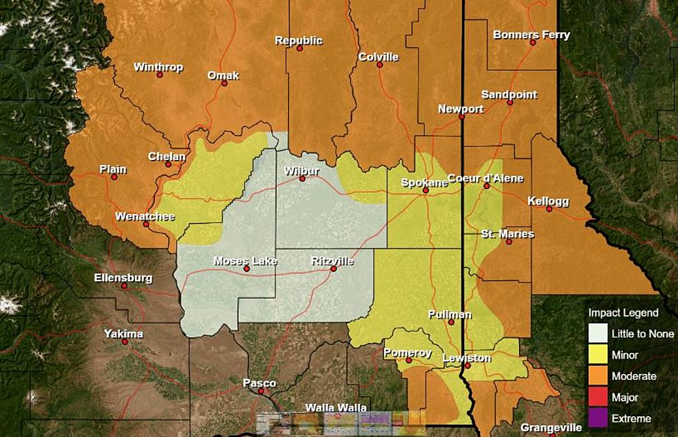
NOAA: The West Coast Is Getting Warmer Dryer
NOAA released its updated Climate Normals Tuesday, an average of weather events between 1991 and 2020, giving us an idea of what an average day looks like temperature wise, what an average month looks like precipitation wise, etc. When taking a look at the past three decades, Marilyn Lohmann, meteorologist with the National Weather Service says one thing is clear.
“That was kind of the overall message, a little bit warmer and a little bit dryer in the western United States.”
She said that increase is very evident when looking at the summer time numbers for the Northwest.
“[We saw a] big temperature change for July where both the high and the low temperature warmed up by almost a degree. That doesn’t sound like a lot, but in weather terms that’s quite a bit warmer temperature, where on the other end some of the winter months cooled, but it was quite small compared to the warmth that we saw coming in July. And then precipitation, we kind of see the driest month shifting from August back into July.”
Lohmann added NOAA’s stats also indicate the number of triple digit highs increased for the Northwest as well.
As far as our immediate weather forecast is concerned, Lohmann says we’ll see some windy conditions as the week continues, with a chance of a very isolated shower, and cooler temperatures heading into the weekend. But she noted the above average temperatures and below average precipitation returns next week.
Click Here to check out NOAA's updated numbers.
If you have a story idea for the PNW Ag Network, call (509) 547-1618, or e-mail gvaagen@cherrycreekmedia.com
More From PNW Ag Network