
Oregon’s Drought Started In Late 2025
Oregon’s near record fire season follows a record low snowpack and that’s no coincidence. NRCS Hydrologist Jason Ward said the dry fire fuels are the result of a culmination of factors: low snowpack, early meltoff, not enough spring rain and warm temperatures.
"We’ve got 88% of the state in moderate to extreme drought," Ward said. "So, that’s a bad situation that we’re in right now, in terms of drought status. The forecast for August, in the Drought Monitor, is calling for persistence of that."
The Driest Stretch Runs From the SW Corner Of The State To The NE
Ward added soil moisture levels are lower than normal, water supplies are challenged, meaning streamflow conditions, statewide, are also exceptionally low. Especially in the snow-dominated areas. And, he noted, the central portion of the state is reporting the worst conditions.
"D3, Extreme Drought, that’s extending from essentially Douglas County all the way up to Union County, in the northeast corner of the state- Umatilla County," Ward said. "That’s probably the most severe swath, in terms of impacts, and that’s going through Cook County and Deschutes, of course.
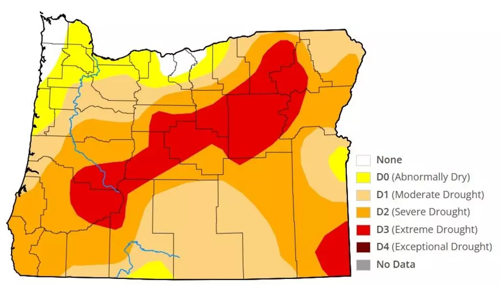
Ward added the Northwest corner of the state, the last hold out with normal soil moisture levels, is expected to dry out in the coming weeks as well.
If you have a story idea for the PNW Ag Network, call (509) 547-9791, or e-mail glenn.vaagen@townsquaremedia.com
More From PNW Ag Network